
South Carolina Neighbors on a Block
A nearby parcel is a geographic fact, while the identity attached to it depends on the record. South Carolina county GIS can show parcel edges and neighboring lots. An assessor can show tax ownership and a tax mailing address. A deed or plat can explain the legal lot or transfer. Voter records and association pages add other kinds of context, each under its own access rules. None is a complete count of current occupants.
| Record source | What it can show nearby | How to reach it |
|---|---|---|
| County GIS | Parcel boundaries, TMS/PIN, adjacent lots and map layers | Free county viewer; coverage differs |
| Assessor | Tax owner, mailing address, situs and exemptions | County portal or office; search parcel/address |
| Register of Deeds and plat | Recorded title, lot/block, easements and prior owners | County index, books or film |
| Voter records | Registration address, status, precinct and districts | Individual check or restricted eligible-voter file |
| Permits and code | Work, complaints or violations and named project parties | City or county portal/request |
| Association directory | Public organization contacts or meeting notices | Organization or district page; member lists usually private |
| Historical directory/news | Earlier occupants, businesses and neighborhood notices | Library, archive or newspaper collection |
Ownership and occupancy should not be treated as the same thing. A tax owner may live elsewhere, and an owner may hold more than one nearby parcel. A mailing address can be an agent or post office box. Renters and other household members are not enumerated in an assessor roll, while a permit applicant or contractor may have no connection to the current household. These sources describe pieces of a block, not a roster of everyone who lives there.
Charleston GIS Nearby Parcel Tools
Charleston County’s public parcel viewer has a defined way to move from one address to the surrounding lots. Search by street or address, zoom to the target, and click its parcel. Pan to neighboring polygons, or use the selection controls when a small block or radius is the question. Parcel outlines are a map layer; ownership still needs to be checked in the county assessor or Register of Deeds.
For a block-scale review, use the viewer controls in sequence:
- Search the street or address and zoom in until individual parcel edges are visible.
- Click the target parcel or enable parcel/address labels to identify its TMS and nearby lots.
- Use Select to collect adjacent parcels; use Buffer with a distance in feet when a radius is more useful than a shared boundary.
- Use Measure to check map distance, then inspect aerial and other available layers for roads, flood areas, zoning or district context.
- Apply Parcel or Address Labels to the selected lots and use Save Labels to CSV to export that selection.
Historic aerial layers can help compare how land changed, but they do not establish a person’s identity or a legal boundary. The exported labels are a list of map parcels, not a list of occupants.
South Carolina Parcel Owners Need Checking
After selecting nearby parcels, write down the TMS or parcel number and search that identifier in the Charleston County property search or the assessor portal for the parcel’s county. Compare the situs, assessed owner, tax mailing address and any homestead or legal-residence field. A tax classification can be useful context, but it does not guarantee that an owner continuously occupies the property. A parcel may also have multiple owners or be held by a trust or business.
For legal ownership, move from the parcel card to the Charleston County Register of Deeds or the corresponding office for the parcel’s county. Use a deed book/page or legal description to find the recorded instrument, then compare names and recording dates. A plat can show subdivision, lot and block, easements, or shared boundaries that are not clear from a street map. Older documents may lack a modern street address, so the lot description and adjacent owners can matter more than the current postal label.
Different counties expose different search fields and online years. Charleston GIS supports parcel, address, street-name or owner searches; county assessor systems elsewhere vary. If the map does not link to an owner, use the TMS or nearby street numbers to reach the assessor, then confirm the legal interest in ROD records. Online cutoffs can send older deeds to courthouse books or microfilm.
Map South Carolina Parcels Around an Address
Start with one normalized street address and work out from its parcel rather than searching an entire city at once. USPS can standardize the delivery line, but county GIS supplies parcel geography. Once the map identifies a target TMS, follow each surrounding lot to the assessor, then use the Register of Deeds for legal title. That order keeps the map, tax owner and recorded owner distinct.
- Normalize the address and locate the parcel in the county GIS viewer.
- Record the target TMS/PIN, then identify touching lots or parcels inside the selected buffer.
- Look up each parcel in the assessor and note tax owner, situs, mailing address and exemption fields.
- Confirm any legal ownership claim against the deed or plat in the county Register of Deeds.
- For a complete record trail along a named street, use the South Carolina street directory lookup.
Do not turn that sequence into a claim about every household. The owner may be absent, the tax mailing line may point somewhere else, and a parcel boundary can run behind or beside a building. If the question is about occupants, the public property roll cannot answer it by itself.
South Carolina Voter Records at Block Scale
MySCVotes checks one known voter by name, county and date of birth as shown on the registration card. It is not a public address-to-name search. The electronic voter file is available only to a registered South Carolina voter under S.C. Code §7-3-20(D)(13), with fees and use restrictions. Its fields may include name, address, precinct, voting districts and participation in the past two statewide primaries and general elections. Participation does not disclose how a person voted; the ballot is secret.
The full-file filters include county and voting district, along with age, sex, race, household, a particular election and registration date. Those filters can help an eligible requester understand the geography of a list, but they do not convert the voter file into an unrestricted neighbor directory. The Family Privacy Protection Act restricts commercial solicitation directed to a person using state-agency information. A matching registration is evidence about a voter record, not proof of present occupancy.
Voting districts can change after redistricting. Check a current address through the state’s official election resources or district map, and avoid treating a past precinct value as a permanent neighborhood boundary.
Columbia Neighborhood Association Sources
South Carolina has no statewide neighborhood-association member directory. Columbia’s official City Council district pages are a useful local example because they list named neighborhood associations and HOAs by district. The examples below come from that directory and are not a complete statewide inventory.
Open the official Columbia Council District association pages to identify public organization listings.
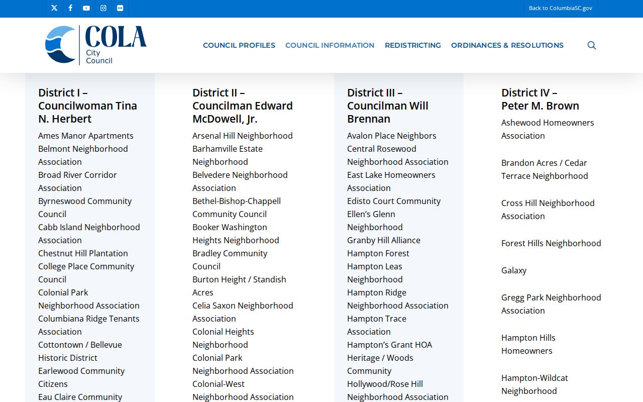
The district pages make association names easier to locate, but they do not provide a statewide roster of members or every household in a neighborhood.
| Public directory example | Why it can help | What it does not prove |
|---|---|---|
| Arsenal Hill; Barhamville Estates | Named organizations listed by Columbia council district | Membership or a person’s current address |
| Belvedere; Granby Hill Alliance | Local neighborhood identity and public organization context | That every nearby parcel belongs to the group |
| Historic Waverly; Melrose Heights | A starting point for public contacts or meeting notices where posted | A complete association or resident list |
| Shandon; Vista; Heathwood; Lake Katherine | Examples of distinct Columbia neighborhood names | Who owns or occupies a particular property |
For HOA records, search the Secretary of State’s corporation records and the county Register of Deeds for recorded declarations or covenants. The Department of Consumer Affairs HOA guidance explains that it does not oversee HOAs and directs questions toward the relevant state or county offices. Association member lists are generally private; public contacts and meeting notices, when published, are a better route for someone hoping to meet people nearby.
Official Records and Neighbor Search Tools
Commercial neighbor-search services are a category of products that combine public records with marketing or purchased datasets. Their compiled profiles can be stale, mix people with similar names or leave removed details in a later copy. An opt-out from a commercial profile does not correct the assessor, court or voter record from which a field may have originated.
| Approach | Useful for | Limit to keep in view |
|---|---|---|
| County GIS and assessor | Locating parcels and checking tax ownership | Does not enumerate occupants |
| ROD and plat | Confirming recorded title and lot boundaries | Older indexes or images may require office access |
| Voter and association records | Checking permitted voter fields or public community contacts | Eligibility, privacy and use rules apply |
| Commercial search category | Broad compiled leads across datasets | Source, date and identity joins may be unclear |
For a block question, an official record is strongest when the requested fact matches what that office records. Verify owners with the assessor and ROD; use organization-published channels to contact an association. Avoid treating a compiled neighbor profile as a current occupant list.
South Carolina Neighbors and Privacy Limits
Public parcel records do not disclose every renter, household member or person who receives mail at a location. Utility customer accounts and delivery data are not public neighborhood lists. A permit record may name an applicant or contractor rather than an owner or occupant. Voter records carry eligibility and use restrictions, and personal information from state agencies cannot be used for prohibited commercial solicitation directed to a South Carolina resident.
The state Address Confidentiality Program gives qualifying survivors a substitute address accepted by state and local agencies and courts. It does not erase older public records, and private companies need not accept the substitute address. When a protected address appears, do not try to infer or locate the hidden residence. Specific protections also apply to some judges, law-enforcement personnel and other participants through separate statutes or programs.
South Carolina’s harassment and stalking law addresses intentional intrusions and conduct such as surveillance or unwanted contact when the legal elements are met. A map or public record is not permission to monitor a neighbor. If a record is wrong, contact the office that maintains it; if there is a direct threat, contact local law enforcement.
Lawful use. Use South Carolina neighbor records for ordinary civic curiosity, community connection and personal safety awareness. Do not use a parcel map, voter file or association page to stalk, harass, intimidate or harm anyone.